Features TrailViewer 2
TrailViewer 2 is a multi purpose tool for navigating in Switzerland and around the world.It can be used online or offline.Link:Feature Descriptions and many videos for fast learning you can find here,
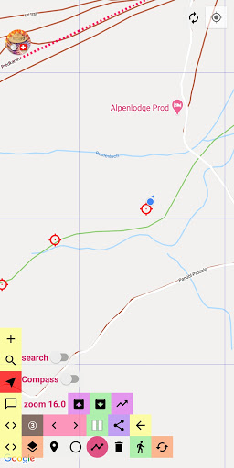
❤ TrailViewer 2:https://drive.google.com/drive/folders/1NnIaExPXC1U4OMnug2ROn0TD6Wg0RsAqDescription:For hiking, freestyle trails or as an orientation guide with compass and location tracker.Simple Tap/Long Press user interface with slide in and out button bars and map gestures.Center map at marker with open info field or current GPS location/position.4 main function selectors which determine the map long press action and the trash button action.Toggle GroundOverlay button (color dark red/brown).A selector spinner gives additional options for choosing the overlay type in dark brown state.GroundOverlays (6×6 km) are downloaded (CH1903) if they are not yet available.You can drag some marker types (9 in total) by long pressing it.Tapping the open info field deletes a marker.Limited geofencing with circles.Total distance, lap distance and azimuth of a polyline for hopping like a rabbit in open terrain.Tapping the blue GPS circle creates a new green reference marker, together a polyline.
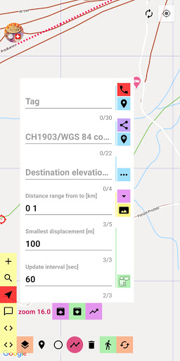
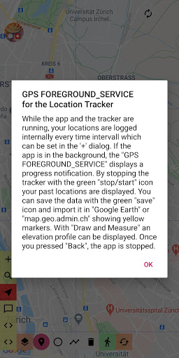
To delete it, tap the green walking man button.Multi tap trash button.You can cycle through 4 transparency levels (0-100%) of the ground overlays (orange button).All public transport stations of Switzerland and many more points of interest can be downloaded from the TrailViewer 2 server (file All.txt) in the search selector.1 SQLite data base which depends on the chosen file *.txt.Then cluster search for Switzerland is available like 4478 resulting in 3 markers.Global search is payed by TrailViewer 2 beyond free tier.Info field with map zoom level, azimuth, distance and azimuth from the last green reference marker to any marker with open info field for navigating to it.Save and restore buttons of location tracker data.Import of a kml-file button (file import.kml in folder Pictures > ch.hrd.trailviewer2 > data) of a downloaded track from the internet.You can cycle through markers forward and backward.Green stop/start button of location tracker.Stopping means displaying the red location tracker markers (track history).You can share any markers location.The + button displays a dialog with some input fields and the Red Phone button for help, videos, full documentation, warnings, rescue tips (dont forget the above https://...
link) and lot of fun stuff.Any markers elevation world wide is available (open info field) within free tier else the developer has to pay (pink button).You can search for nearby points of interest in Switzerland as clusters (marker with open info field is the center, tap trash icon to have full functionality, needs SQLite data base, yellow button).TrailViewer 2 uses GroundOverlays, Markers, Circles, Polylines, Marker Clusters and a Kml-Layer.No user data is sent to a server for spying.Its a matter of traditional Swiss style.TrailViewer 2 is completely noncommercial.
Social Features
Connect and share with friends and the community.
Gaming Features
Enjoy immersive gaming experience with various game modes.
Camera Features
Advanced camera features with editing capabilities.
See the TrailViewer 2 in Action
Get the App Today
Available for Android 8.0 and above